Understanding FLINT#
Countries recognise the importance of improving decision making and supporting land sector policies to reduce greenhouse gas (GHG) emissions and increase removals. At the same time, there is heightened attention globally on transparency in climate action to support the goals of the Paris Agreement and in supporting transitions to achieve the Sustainable Development Goals. The Full Lands Integration Tool (FLINT) is an open-source platform to estimate emissions and removals of greenhouse gases from the land sector using modules that perform specific analyses of carbon flows.
The FLINT is a second-generation tool aimed to facilitate the implementation and operation of land sector emissions estimation systems worldwide. It was developed through cooperation between Kenya, Australia and Canada and incorporates lessons learned from the development of the CBM-CFS3 (Canada) and FullCAM (Australia). Some core features are:
A full-mass balance framework able to meet all IPCC requirements.
Possibilities for customisation to meet national policy and reporting requirements.
A modular system that allows the use of individual and exchangeable modules.
Ability to operate in a spatially explicit way.
Ability to produce fine resolution time series data.
Ability to report on the past and to generate projections.
Flexibility for representing all land uses.
Providing a framework for continuous improvement.
Open-source software managed by moja global under the Linux Foundation.
The FLINT provides a framework to progressively develop MRV-related systems, data and capacities. By this means, countries can start with simple implementations using existing global data sets (Tier 1) and then gradually move to more complex calculation approaches, using national and regional information (Tier 2 or 3).
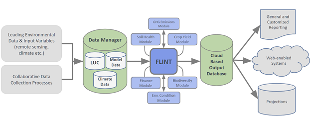
The basic role of the FLINT is to coordinate the interaction of data (e.g. spatial data, non-spatial data, carbon pools, variables, fluxes) and modules. It also manages computational outputs. FLINT-compatible modules are discreet software packages that can be attached to the FLINT. It is possible to differentiate between calculation modules and functionality modules. Calculation modules can change the state of variables and pools for pixels over a sequence of steps. Functionality modules do not apply changes to variables or pools but affect the utility of the FLINT by e.g. aggregating data or generating outputs.
A unique configuration of modules attached to the FLINT is referred to as implementation (described in the picture below). Existing FLINT implementations are SLEEK-FLINT, GCBM and FLINTpro. SLEEK-FLINT uses the Chapman-Richards function as the basis of one of it’s forest growth models. GCBM uses growth-and-yield curves that describe the relationship between stand age and stand volume.
Contents: